Final Project: Mapping the labour characteristic between male and female across Canada province
Cartographic Design for comparing the median income between men versus women in 2015.
Geographic Information Science & Computer Science
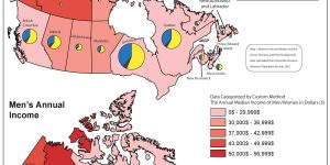
Cartographic Design for comparing the median income between men versus women in 2015.

Being the largest city in Canada, Toronto has a population of over 2.5 million people, but the housing problems in the city has been worsening gradually. Therefore, we aim to address this social issue by looking for potential sites for new affordable housing in our project. We will be using ArcGIS to map potential locations and conduct spatial analysis on existing data's of current affordable housing including their surrounding environments.
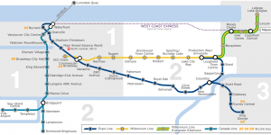
In this project, we will be using ArcGIS to map the ideal Skytrain route for the proposed Translink plan from Arbutus station to UBC.