Final Project: Mapping the labour characteristic between male and female across Canada province
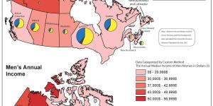
Cartographic Design for comparing the median income between men versus women in 2015.
Final Project (Look At The Economic Impact Of COVID-19 In Vancouver)
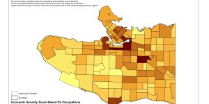
This project highlights mapping the severity of economically-impacted population and business across Vancouver using MCE & mapping the at-risk population to identify areas with higher levels of at-risk groups
Lectures

It covers weekly lectures with notes on three topics health geography, landscape ecology, and crime geography
Paper Review On Crime Geography

Review on the use of Geographic Weighted Regression and Ordinary Least Square in Investigating Temporal and Spatial Effects of Urban Planning Variables on Crime Rate
Lab 3: Introduction to CrimeStat for Crime Analysis
This lab focuses on Crime Analysis looking at Crime Incidents in Nepean City of Ontario from 2005-2006
Paper Review On Health Geography

Review on applying GIS multi-criteria-decision-making techniques AHP and FAHP to find hazard zonation model for hand, feet, and mouth transmitted disease
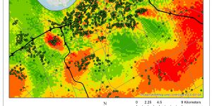
Lab 2: Geographically-Weighted Regression
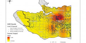
This report is looking at the relationship between Child’s language skill and a set of other variables using spatial analysis
Paper Review For Landscape Ecology

Review on Spatial alteration of fragmented forest landscape for improving structural quality of habitat
Lab 1: Exploring FragStats Software
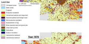
This report is utilizing FragStats to analyze land use and land cover changes from 1966 to 1976 in Edmonton, Alberta
Final Project: Mapping Potential Affordable Housing Locations in Toronto
Being the largest city in Canada, Toronto has a population of over 2.5 million people, but the housing problems in the city has been worsening gradually. Therefore, we aim to address this social issue by looking for potential sites for new affordable housing in our project. We will be using ArcGIS to map potential locations and conduct spatial analysis on existing data's of current affordable housing including their surrounding environments.
Final Project: Planning TransLink stations from Arbutus station to UBC
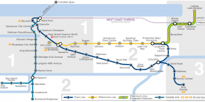
In this project, we will be using ArcGIS to map the ideal Skytrain route for the proposed Translink plan from Arbutus station to UBC.